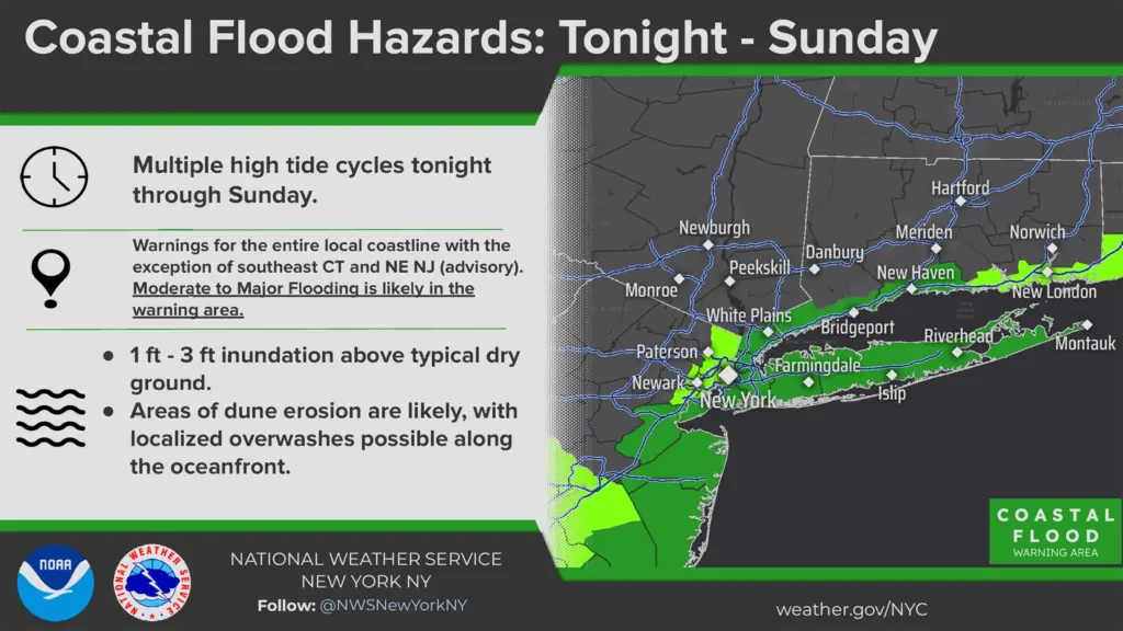
The National Weather Service has specifically alerted residents of Friday evening’s high tide as the greatest concern, with a full moon raising tides higher than normal.
Multiple Flood Warnings Starting Tonight
The first nor’easter of the season will begin affecting the region Friday, coinciding with this weekend’s full moon and unfortunately raising tides well above normal. The National Weather Service has issued Coastal Flood Warnings for the entire local coastline, with the exception of southeast Connecticut and northeast New Jersey. Moderate to major flooding is likely in the warning area, with 1 to 3 feet of inundation above ground that is normally dry, with Friday evening’s high tide cycle marked as the period of greatest concern.
Advisories earlier in the week warned that areas on the western South Shore bays, including the area around JFK and Jamaica Bay, along with North Shore communities from Little Neck to Great Neck and Glen Cove, should watch for moderate flooding. The latest update extends warnings to the entire coastline, but residents of those previously named areas should remain especially cautious around shorelines and flood zones.
Rep. Tom Suozzi, whose district includes the waterfront neighborhoods of northeast Queens and Nassau’s North Shore, urged residents to get ahead of it. “With a full moon this weekend and higher-than-normal tides, our waterfront communities should be especially prepared,” Suozzi wrote Thursday. “If you live in a flood-prone area, keep an eye on high-tide times, secure outdoor items, and move vehicles to higher ground if necessary.”
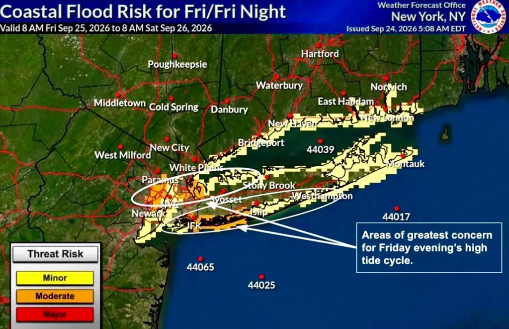
Photo: NWS New York coastal flood risk outlook for today, Friday September 25th, issued September 24, 2026, 5:08 a.m. EDT, and shared by Rep. Tom Suozzi’s office. Please note that the entire local coastline is now under moderate risk, and residents in areas labelled as moderate risk above should be particularly cautious around coastlines and flood zones.
Expect Effects to Last the Entire Weekend
Winds have approached gusts of 40 mph ahead of the storm, and will strengthen as the storm approaches late Friday. Gusts of 40 to 50 mph are expected on Long Island through Saturday and Sunday, with eastern Long Island possibly approaching 60 mph, enough to bring down trees and power lines. Meanwhile, the city could see gusts of 40 to 50 mph.
Rain moves in Friday afternoon, and continues on and off through the weekend. New York City is forecast to pick up 2 to 3 inches, while eastern Long Island could see 3 to 4 inches, with isolated spots of up to 6 inches. Low-lying areas around Jamaica Bay, the Rockaways, and parts of Staten Island could flood during the Friday evening and Saturday morning high tides, and repeated tide cycles through the entirety of the weekend may cause chaotic flooding even during spells of relatively light rain.
Conditions improve late Saturday into Sunday as the storm pulls offshore, however expect bands of rain to wrap around and hit the northeast until Monday and wind gusts that can still approach 50 mph.
It is recommended to move cars off flood-prone blocks before Friday evening, bring in anything the wind can carry, never drive through tidal flooding, and stay clear of downed wires. As the storm approaches and evolves, check high tide times for your shoreline if you live near the coast, and sign up for real-time alerts at nyc.gov/notify.
Forecast details in this article are sourced from the National Weather Service New York briefing packet, which is updated throughout the weekend at https://www.weather.gov/media/okx/DssPacket.pdf, feel free to review the information provided by the National Weather Service here as they provide further updates throughout the weekend.